

Key Insights
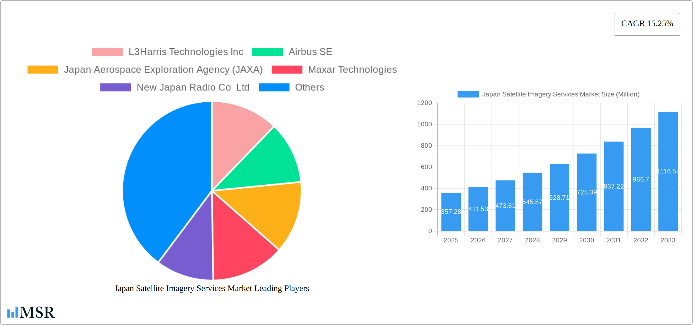
The Japan Satellite Imagery Services market, valued at $357.28 million in 2025, is projected to experience robust growth, fueled by a compound annual growth rate (CAGR) of 15.25% from 2025 to 2033. This expansion is driven primarily by increasing government investment in infrastructure development, particularly within transportation and construction sectors. The rising demand for precise geospatial data for urban planning, disaster management, and environmental monitoring further propels market growth. Advancements in sensor technology, providing higher resolution and more frequent imagery acquisition, are also key contributing factors. The diverse applications across government agencies, the construction and logistics industries, and the military and defense sectors showcase the market's broad appeal. Specific regional growth is likely to be strongest in the Kanto region due to its high population density and concentration of businesses. However, steady growth is anticipated across all major regions (Kanto, Kansai, Chubu, Kyushu, Tohoku) as the benefits of satellite imagery become increasingly recognized.
Competition in the market is intense, with both international and domestic players vying for market share. Established players such as L3Harris Technologies Inc., Airbus SE, and Maxar Technologies compete alongside Japanese companies like NTT Data Corporation and RESTEC. These companies offer a range of services, from raw imagery acquisition and processing to value-added analytics and tailored solutions for specific industries. The increasing availability of cloud-based platforms and data analytics services is also shaping the competitive landscape, facilitating greater accessibility and affordability of satellite imagery data and analysis. The market's future trajectory depends on factors such as continued technological advancements, government policy support for spatial data infrastructure, and the increasing awareness of the value of geospatial intelligence across various sectors.
Japan Satellite Imagery Services Market: A Comprehensive Report (2019-2033)
This in-depth report provides a comprehensive analysis of the Japan Satellite Imagery Services Market, offering invaluable insights for industry stakeholders, investors, and strategic decision-makers. Covering the period from 2019 to 2033, with a base year of 2025 and a forecast period of 2025-2033, this report meticulously examines market dynamics, key segments, leading players, and emerging opportunities. The market is projected to reach xx Million by 2033, exhibiting a CAGR of xx% during the forecast period. The report incorporates detailed analysis of key players such as L3Harris Technologies Inc, Airbus SE, Japan Aerospace Exploration Agency (JAXA), Maxar Technologies, New Japan Radio Co Ltd, NTT Data Corporation, Remote Sensing Technology Center of Japan (RESTEC), Kokusai Kogyo Co Ltd, PASCO Corporation, and Mitsubishi Electric.
Japan Satellite Imagery Services Market Concentration & Dynamics
The Japan satellite imagery services market exhibits a moderately concentrated landscape, with a few dominant players holding significant market share. However, the presence of numerous smaller, specialized firms fosters a dynamic and innovative ecosystem. Government regulations, particularly concerning data security and national security applications, play a crucial role in shaping market dynamics. The market faces competition from alternative geospatial data sources, such as aerial photography and LiDAR, but satellite imagery maintains its edge in terms of coverage, resolution, and frequency of acquisition in many applications. End-user trends show a growing preference for high-resolution, readily accessible data, fueling demand for advanced analytics and cloud-based platforms.
- Market Concentration: The top 5 players account for approximately xx% of the market share in 2025.
- M&A Activity: The historical period (2019-2024) witnessed approximately xx M&A deals, with a notable increase in recent years reflecting consolidation within the sector.
- Innovation Ecosystem: The market is characterized by ongoing technological advancements in sensor technology, data processing, and analytics, driving the development of novel applications.
- Regulatory Framework: Government regulations related to data privacy, security, and licensing influence market access and operational strategies for companies.
Japan Satellite Imagery Services Market Industry Insights & Trends
The Japan satellite imagery services market is experiencing robust growth, driven by increasing demand across various sectors. The market size was valued at xx Million in 2025 and is projected to reach xx Million by 2033, exhibiting a Compound Annual Growth Rate (CAGR) of xx%. This growth is fueled by several factors. Government initiatives promoting the use of geospatial data in infrastructure development and disaster management are significantly boosting market demand. Technological advancements, such as improved sensor technology and the proliferation of high-resolution imagery, are enhancing the quality and accessibility of satellite data. Furthermore, the rising adoption of cloud-based platforms for data processing and analysis is facilitating broader access and utilization of satellite imagery services. Evolving consumer behaviors are also playing a significant role, with increased reliance on location-based services and real-time data. The increasing use of AI and machine learning is streamlining analytics, accelerating insights generation from satellite imagery.

Key Markets & Segments Leading Japan Satellite Imagery Services Market
The Government sector is the dominant end-user segment, accounting for approximately xx% of the market in 2025, driven by its large-scale projects in infrastructure, security, and disaster management. The Geospatial Data Acquisition and Mapping application segment leads in terms of revenue, largely due to extensive government spending and the growing private sector investment in location-based services and urban planning. Other significant end-user segments include Construction, Transportation and Logistics, Military and Defense, Forestry and Agriculture.
Key Drivers by Segment:
- Government: Significant investments in infrastructure development, national security, and disaster preparedness.
- Construction: Demand for high-resolution imagery for site surveys, project monitoring, and urban planning.
- Transportation and Logistics: Optimization of transportation routes, efficient logistics management, and traffic monitoring.
- Military and Defense: Intelligence gathering, surveillance, and border security.
- Forestry and Agriculture: Precision farming, forest monitoring, and environmental conservation.
Japan Satellite Imagery Services Market Product Developments
Recent product developments focus on higher-resolution imagery, advanced analytics capabilities, and improved data accessibility through cloud-based platforms. The integration of AI and machine learning algorithms enhances data processing and analysis, allowing for faster and more accurate insights. These innovations provide significant competitive edges, enabling service providers to offer more comprehensive and value-added solutions to clients.
Challenges in the Japan Satellite Imagery Services Market Market
The market faces challenges such as stringent data regulations, high initial investment costs for satellite infrastructure, and intense competition among service providers. Supply chain disruptions can also impact the availability of satellite imagery and related services, and the need for highly specialized expertise contributes to higher operational costs. These factors can significantly affect profitability and growth projections.
Forces Driving Japan Satellite Imagery Services Market Growth
Key drivers include increased government investment in infrastructure projects, rising demand for high-resolution imagery in diverse applications, and technological advancements in satellite sensor technology and data analytics. Economic growth and urbanization contribute to the demand for efficient urban planning and resource management solutions. Favorable government policies and regulations also stimulate market expansion.
Challenges in the Japan Satellite Imagery Services Market Market
Long-term growth will be propelled by the ongoing development of innovative satellite technologies, strategic partnerships between data providers and analytics companies, and expanding applications into new sectors such as renewable energy monitoring and environmental conservation. Increased accessibility of satellite data via cloud-based platforms will unlock new market segments.
Emerging Opportunities in Japan Satellite Imagery Services Market
Emerging opportunities include the increasing use of AI and machine learning in data analysis, the integration of satellite data with other geospatial sources, and the growth of new applications in precision agriculture, environmental monitoring, and infrastructure management. Expanding into international markets and offering customized solutions to address specific customer needs will also create substantial growth opportunities.
Leading Players in the Japan Satellite Imagery Services Market Sector
- L3Harris Technologies Inc
- Airbus SE
- Japan Aerospace Exploration Agency (JAXA)
- Maxar Technologies
- New Japan Radio Co Ltd
- NTT Data Corporation
- Remote Sensing Technology Center of Japan (RESTEC)
- Kokusai Kogyo Co Ltd
- PASCO Corporation
- Mitsubishi Electric
Key Milestones in Japan Satellite Imagery Services Market Industry
- November 2022: Japan Space Imaging Corporation partnered with Satellite Vu to launch a constellation providing high-resolution thermal data, expanding the market's capabilities.
- January 2023: Axelspace's collaboration with New Space Intelligence accelerates the development and adoption of new satellite data applications. This partnership signifies the growing demand for innovative uses of satellite imagery.
Strategic Outlook for Japan Satellite Imagery Services Market Market
The future of the Japan satellite imagery services market is bright, driven by ongoing technological innovations, expanding application areas, and increasing demand for data-driven decision-making across various sectors. Strategic partnerships and investments in research and development will be critical for companies to maintain a competitive edge. The market's potential for growth is considerable, particularly as the demand for high-resolution, readily accessible satellite data continues to expand.
Japan Satellite Imagery Services Market Segmentation
-
1. Application
- 1.1. Geospatial Data Acquisition and Mapping
- 1.2. Natural Resource Management
- 1.3. Surveillance and Security
- 1.4. Conservation and Research
- 1.5. Disaster Management
- 1.6. Intelligence
-
2. End-User
- 2.1. Government
- 2.2. Construction
- 2.3. Transportation and Logistics
- 2.4. Military and Defense
- 2.5. Forestry and Agriculture
- 2.6. Other End-Users
Japan Satellite Imagery Services Market Segmentation By Geography
- 1. Japan

Japan Satellite Imagery Services Market REPORT HIGHLIGHTS
| Aspects | Details |
|---|---|
| Study Period | 2019-2033 |
| Base Year | 2024 |
| Estimated Year | 2025 |
| Forecast Period | 2025-2033 |
| Historical Period | 2019-2024 |
| Growth Rate | CAGR of 15.25% from 2019-2033 |
| Segmentation |
|
Table of Contents
- 1. Introduction
- 1.1. Research Scope
- 1.2. Market Segmentation
- 1.3. Research Methodology
- 1.4. Definitions and Assumptions
- 2. Executive Summary
- 2.1. Introduction
- 3. Market Dynamics
- 3.1. Introduction
- 3.2. Market Drivers
- 3.2.1. Infrastructural Development in Japan; Increasing Requirement for Mapping and Navigation System
- 3.3. Market Restrains
- 3.3.1. Regulatory and Legal Challenges
- 3.4. Market Trends
- 3.4.1. Infrastructural Development in Japan
- 4. Market Factor Analysis
- 4.1. Porters Five Forces
- 4.2. Supply/Value Chain
- 4.3. PESTEL analysis
- 4.4. Market Entropy
- 4.5. Patent/Trademark Analysis
- 5. Japan Satellite Imagery Services Market Analysis, Insights and Forecast, 2019-2031
- 5.1. Market Analysis, Insights and Forecast - by Application
- 5.1.1. Geospatial Data Acquisition and Mapping
- 5.1.2. Natural Resource Management
- 5.1.3. Surveillance and Security
- 5.1.4. Conservation and Research
- 5.1.5. Disaster Management
- 5.1.6. Intelligence
- 5.2. Market Analysis, Insights and Forecast - by End-User
- 5.2.1. Government
- 5.2.2. Construction
- 5.2.3. Transportation and Logistics
- 5.2.4. Military and Defense
- 5.2.5. Forestry and Agriculture
- 5.2.6. Other End-Users
- 5.3. Market Analysis, Insights and Forecast - by Region
- 5.3.1. Japan
- 5.1. Market Analysis, Insights and Forecast - by Application
- 6. Kanto Japan Satellite Imagery Services Market Analysis, Insights and Forecast, 2019-2031
- 7. Kansai Japan Satellite Imagery Services Market Analysis, Insights and Forecast, 2019-2031
- 8. Chubu Japan Satellite Imagery Services Market Analysis, Insights and Forecast, 2019-2031
- 9. Kyushu Japan Satellite Imagery Services Market Analysis, Insights and Forecast, 2019-2031
- 10. Tohoku Japan Satellite Imagery Services Market Analysis, Insights and Forecast, 2019-2031
- 11. Competitive Analysis
- 11.1. Market Share Analysis 2024
- 11.2. Company Profiles
- 11.2.1 L3Harris Technologies Inc
- 11.2.1.1. Overview
- 11.2.1.2. Products
- 11.2.1.3. SWOT Analysis
- 11.2.1.4. Recent Developments
- 11.2.1.5. Financials (Based on Availability)
- 11.2.2 Airbus SE
- 11.2.2.1. Overview
- 11.2.2.2. Products
- 11.2.2.3. SWOT Analysis
- 11.2.2.4. Recent Developments
- 11.2.2.5. Financials (Based on Availability)
- 11.2.3 Japan Aerospace Exploration Agency (JAXA)
- 11.2.3.1. Overview
- 11.2.3.2. Products
- 11.2.3.3. SWOT Analysis
- 11.2.3.4. Recent Developments
- 11.2.3.5. Financials (Based on Availability)
- 11.2.4 Maxar Technologies
- 11.2.4.1. Overview
- 11.2.4.2. Products
- 11.2.4.3. SWOT Analysis
- 11.2.4.4. Recent Developments
- 11.2.4.5. Financials (Based on Availability)
- 11.2.5 New Japan Radio Co Ltd
- 11.2.5.1. Overview
- 11.2.5.2. Products
- 11.2.5.3. SWOT Analysis
- 11.2.5.4. Recent Developments
- 11.2.5.5. Financials (Based on Availability)
- 11.2.6 NTT Data Corporation
- 11.2.6.1. Overview
- 11.2.6.2. Products
- 11.2.6.3. SWOT Analysis
- 11.2.6.4. Recent Developments
- 11.2.6.5. Financials (Based on Availability)
- 11.2.7 Remote Sensing Technology Center of Japan (RESTEC)
- 11.2.7.1. Overview
- 11.2.7.2. Products
- 11.2.7.3. SWOT Analysis
- 11.2.7.4. Recent Developments
- 11.2.7.5. Financials (Based on Availability)
- 11.2.8 Kokusai Kogyo Co Ltd
- 11.2.8.1. Overview
- 11.2.8.2. Products
- 11.2.8.3. SWOT Analysis
- 11.2.8.4. Recent Developments
- 11.2.8.5. Financials (Based on Availability)
- 11.2.9 PASCO Corporation
- 11.2.9.1. Overview
- 11.2.9.2. Products
- 11.2.9.3. SWOT Analysis
- 11.2.9.4. Recent Developments
- 11.2.9.5. Financials (Based on Availability)
- 11.2.10 Mitsubishi Electric
- 11.2.10.1. Overview
- 11.2.10.2. Products
- 11.2.10.3. SWOT Analysis
- 11.2.10.4. Recent Developments
- 11.2.10.5. Financials (Based on Availability)
- 11.2.1 L3Harris Technologies Inc
List of Figures
- Figure 1: Japan Satellite Imagery Services Market Revenue Breakdown (Million, %) by Product 2024 & 2032
- Figure 2: Japan Satellite Imagery Services Market Share (%) by Company 2024
List of Tables
- Table 1: Japan Satellite Imagery Services Market Revenue Million Forecast, by Region 2019 & 2032
- Table 2: Japan Satellite Imagery Services Market Volume K Unit Forecast, by Region 2019 & 2032
- Table 3: Japan Satellite Imagery Services Market Revenue Million Forecast, by Application 2019 & 2032
- Table 4: Japan Satellite Imagery Services Market Volume K Unit Forecast, by Application 2019 & 2032
- Table 5: Japan Satellite Imagery Services Market Revenue Million Forecast, by End-User 2019 & 2032
- Table 6: Japan Satellite Imagery Services Market Volume K Unit Forecast, by End-User 2019 & 2032
- Table 7: Japan Satellite Imagery Services Market Revenue Million Forecast, by Region 2019 & 2032
- Table 8: Japan Satellite Imagery Services Market Volume K Unit Forecast, by Region 2019 & 2032
- Table 9: Japan Satellite Imagery Services Market Revenue Million Forecast, by Country 2019 & 2032
- Table 10: Japan Satellite Imagery Services Market Volume K Unit Forecast, by Country 2019 & 2032
- Table 11: Kanto Japan Satellite Imagery Services Market Revenue (Million) Forecast, by Application 2019 & 2032
- Table 12: Kanto Japan Satellite Imagery Services Market Volume (K Unit) Forecast, by Application 2019 & 2032
- Table 13: Kansai Japan Satellite Imagery Services Market Revenue (Million) Forecast, by Application 2019 & 2032
- Table 14: Kansai Japan Satellite Imagery Services Market Volume (K Unit) Forecast, by Application 2019 & 2032
- Table 15: Chubu Japan Satellite Imagery Services Market Revenue (Million) Forecast, by Application 2019 & 2032
- Table 16: Chubu Japan Satellite Imagery Services Market Volume (K Unit) Forecast, by Application 2019 & 2032
- Table 17: Kyushu Japan Satellite Imagery Services Market Revenue (Million) Forecast, by Application 2019 & 2032
- Table 18: Kyushu Japan Satellite Imagery Services Market Volume (K Unit) Forecast, by Application 2019 & 2032
- Table 19: Tohoku Japan Satellite Imagery Services Market Revenue (Million) Forecast, by Application 2019 & 2032
- Table 20: Tohoku Japan Satellite Imagery Services Market Volume (K Unit) Forecast, by Application 2019 & 2032
- Table 21: Japan Satellite Imagery Services Market Revenue Million Forecast, by Application 2019 & 2032
- Table 22: Japan Satellite Imagery Services Market Volume K Unit Forecast, by Application 2019 & 2032
- Table 23: Japan Satellite Imagery Services Market Revenue Million Forecast, by End-User 2019 & 2032
- Table 24: Japan Satellite Imagery Services Market Volume K Unit Forecast, by End-User 2019 & 2032
- Table 25: Japan Satellite Imagery Services Market Revenue Million Forecast, by Country 2019 & 2032
- Table 26: Japan Satellite Imagery Services Market Volume K Unit Forecast, by Country 2019 & 2032
Frequently Asked Questions
1. What is the projected Compound Annual Growth Rate (CAGR) of the Japan Satellite Imagery Services Market?
The projected CAGR is approximately 15.25%.
2. Which companies are prominent players in the Japan Satellite Imagery Services Market?
Key companies in the market include L3Harris Technologies Inc, Airbus SE, Japan Aerospace Exploration Agency (JAXA), Maxar Technologies, New Japan Radio Co Ltd, NTT Data Corporation, Remote Sensing Technology Center of Japan (RESTEC), Kokusai Kogyo Co Ltd, PASCO Corporation, Mitsubishi Electric.
3. What are the main segments of the Japan Satellite Imagery Services Market?
The market segments include Application, End-User.
4. Can you provide details about the market size?
The market size is estimated to be USD 357.28 Million as of 2022.
5. What are some drivers contributing to market growth?
Infrastructural Development in Japan; Increasing Requirement for Mapping and Navigation System.
6. What are the notable trends driving market growth?
Infrastructural Development in Japan.
7. Are there any restraints impacting market growth?
Regulatory and Legal Challenges.
8. Can you provide examples of recent developments in the market?
January 2023: Axelspace announced that the company signed an agreement with New Space Intelligence which is a Japanese satellite imagery analysis service provider company. With this partnership, both companies will work together to promote the expansion of satellite data utilization by developing new applications using satellite imagery.
9. What pricing options are available for accessing the report?
Pricing options include single-user, multi-user, and enterprise licenses priced at USD 3800, USD 4500, and USD 5800 respectively.
10. Is the market size provided in terms of value or volume?
The market size is provided in terms of value, measured in Million and volume, measured in K Unit.
11. Are there any specific market keywords associated with the report?
Yes, the market keyword associated with the report is "Japan Satellite Imagery Services Market," which aids in identifying and referencing the specific market segment covered.
12. How do I determine which pricing option suits my needs best?
The pricing options vary based on user requirements and access needs. Individual users may opt for single-user licenses, while businesses requiring broader access may choose multi-user or enterprise licenses for cost-effective access to the report.
13. Are there any additional resources or data provided in the Japan Satellite Imagery Services Market report?
While the report offers comprehensive insights, it's advisable to review the specific contents or supplementary materials provided to ascertain if additional resources or data are available.
14. How can I stay updated on further developments or reports in the Japan Satellite Imagery Services Market?
To stay informed about further developments, trends, and reports in the Japan Satellite Imagery Services Market, consider subscribing to industry newsletters, following relevant companies and organizations, or regularly checking reputable industry news sources and publications.
Methodology
Step 1 - Identification of Relevant Samples Size from Population Database


Step 2 - Approaches for Defining Global Market Size (Value, Volume* & Price*)

Note*: In applicable scenarios
Step 3 - Data Sources
Primary Research
- Web Analytics
- Survey Reports
- Research Institute
- Latest Research Reports
- Opinion Leaders
Secondary Research
- Annual Reports
- White Paper
- Latest Press Release
- Industry Association
- Paid Database
- Investor Presentations

Step 4 - Data Triangulation
Involves using different sources of information in order to increase the validity of a study
These sources are likely to be stakeholders in a program - participants, other researchers, program staff, other community members, and so on.
Then we put all data in single framework & apply various statistical tools to find out the dynamic on the market.
During the analysis stage, feedback from the stakeholder groups would be compared to determine areas of agreement as well as areas of divergence
