

Key Insights
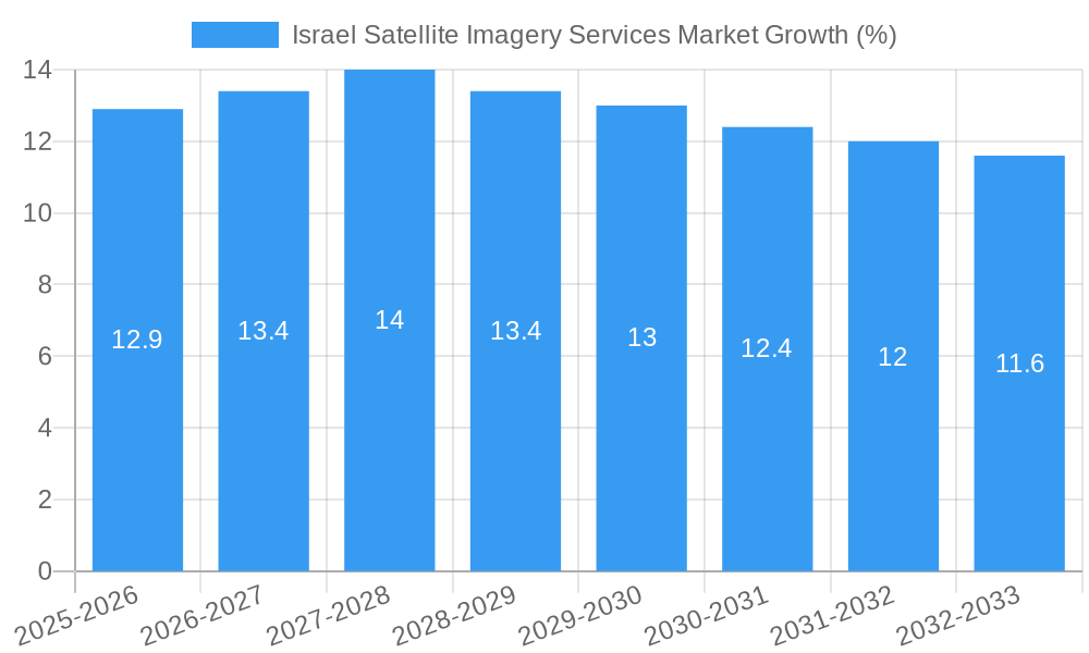
The Israel satellite imagery services market is experiencing robust growth, driven by increasing government investment in national security and infrastructure development, coupled with the burgeoning adoption of satellite imagery in various sectors. The market's Compound Annual Growth Rate (CAGR) of 8.63% from 2019 to 2024 indicates a significant expansion, projected to continue into the forecast period (2025-2033). Key application segments such as geospatial data acquisition and mapping, natural resource management, and surveillance and security are primary contributors to this growth. The strong presence of established players like ImageSat International N.V. (iSi), Airbus Group Inc., and Trimble Navigation, alongside emerging technology companies, fosters a competitive yet innovative market environment. Government initiatives promoting technological advancements and the nation's strategic location further solidify Israel's position as a significant player in the global satellite imagery market. The end-user segments, notably Government, Military and Defense, and Construction are showing particularly strong demand for high-resolution imagery and advanced analytical services.
The market's future trajectory hinges on continued technological advancements in satellite sensor technology, data processing capabilities, and the development of sophisticated analytical tools. Further growth is expected from the increasing integration of AI and machine learning for enhanced image analysis and the expansion of applications in sectors like precision agriculture and disaster response. While data limitations may presently hamper precise market sizing, the available information, coupled with the observed trends, strongly suggests a continuously expanding market. Challenges such as data privacy concerns and regulatory frameworks need careful consideration; however, the overall prospects for the Israeli satellite imagery services market remain exceptionally positive over the next decade, with significant potential for both domestic and international expansion.
Israel Satellite Imagery Services Market Report: 2019-2033
This comprehensive report provides an in-depth analysis of the Israel Satellite Imagery Services Market, offering valuable insights for industry stakeholders, investors, and strategic decision-makers. The study period spans from 2019 to 2033, with 2025 serving as the base and estimated year. The report delves into market dynamics, key segments, leading players, and future growth opportunities, forecasting market trends through 2033. The market is valued at xx Million in 2025 and is projected to reach xx Million by 2033, exhibiting a CAGR of xx%.
Israel Satellite Imagery Services Market Market Concentration & Dynamics
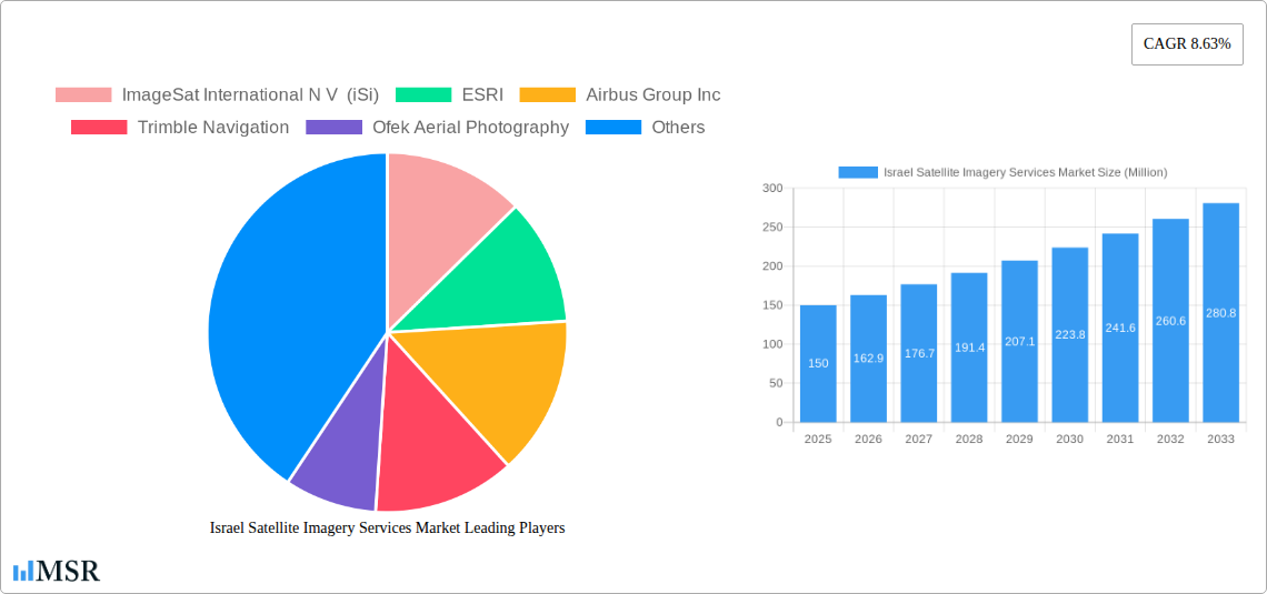
The Israel satellite imagery services market exhibits a moderately concentrated landscape, with a few key players holding significant market share. ImageSat International N V (iSi) and A TAL Satellite Imagery are major domestic players, while international giants like Airbus Group Inc and Google LLC exert considerable influence. The market is characterized by a dynamic innovation ecosystem, driven by advancements in satellite technology, data analytics, and AI. Stringent regulatory frameworks, particularly concerning national security and data privacy, shape market operations. Substitute products, such as aerial photography and LiDAR, compete for market share, but satellite imagery maintains a significant edge in terms of coverage and resolution.
End-user trends show a growing demand for high-resolution imagery across various sectors, including government, defense, and construction. The market has witnessed a moderate level of M&A activity in recent years, with xx deals recorded between 2019 and 2024. These transactions primarily involve smaller players being acquired by larger companies seeking to expand their capabilities and market reach. Future market concentration is likely to increase further, driven by ongoing consolidation and the emergence of new technologies.
- Market Share: ImageSat International N V (iSi) holds approximately xx% market share.
- M&A Activity: An average of xx M&A deals per year were observed during 2019-2024.
- Regulatory Framework: Stringent data privacy regulations influence market dynamics.
- Substitute Products: Aerial photography and LiDAR present alternative solutions, but with limitations.
Israel Satellite Imagery Services Market Industry Insights & Trends
The Israel Satellite Imagery Services Market is experiencing robust growth, fueled by escalating demand across various sectors. Technological advancements such as increased resolution capabilities, improved data analytics tools, and the integration of AI are driving market expansion. The market size was valued at xx Million in 2024 and is projected to reach xx Million by 2033. This growth is underpinned by several factors including increasing government investment in defense and intelligence gathering, rising infrastructure development projects, and the expanding use of geospatial data for environmental monitoring and urban planning. The consistent demand from the Government sector is primarily driving the growth of this market. Consumer behavior is shifting toward greater reliance on precise, real-time data for informed decision-making, bolstering the demand for advanced satellite imagery services. The market is also witnessing the emergence of new business models, such as cloud-based platforms offering on-demand access to imagery and analytics.
Key Markets & Segments Leading Israel Satellite Imagery Services Market
The Government sector is the dominant end-user of satellite imagery services in Israel, followed by the Military and Defense sector. Within the application segments, Surveillance and Security and Intelligence applications are leading in terms of market share and growth potential.
Key Drivers by Segment:
- Government: High government spending on defense and national security.
- Military and Defense: Strategic intelligence gathering and operational planning.
- Construction: Infrastructure project planning and monitoring.
- Surveillance and Security: Border monitoring and crime prevention.
- Intelligence: Real-time intelligence gathering and analysis.
Dominance Analysis: The Government sector dominates due to its significant budgetary allocation for national security and strategic intelligence. The Military and Defense sector holds a substantial market share due to its dependence on high-resolution imagery for operational purposes.
Israel Satellite Imagery Services Market Product Developments
Recent advancements in satellite technology have resulted in the introduction of higher-resolution imagery, improved spectral capabilities, and more sophisticated analytics tools. These innovations have broadened the applications of satellite imagery, increasing its utility across various sectors. The development of cloud-based platforms has also enhanced accessibility and affordability of satellite imagery services, spurring wider adoption. The competitive landscape is characterized by ongoing innovation in data analytics and AI-powered image processing, generating significant competitive edges for providers who can offer advanced processing capabilities and insightful data interpretations.
Challenges in the Israel Satellite Imagery Services Market Market
The Israel satellite imagery services market faces several challenges. Stringent regulations surrounding data privacy and national security can limit data accessibility and application. Supply chain disruptions impacting satellite manufacturing and launch schedules may cause delays and increase costs. Intense competition among established players and emerging technology providers creates pressure on pricing and profitability. These combined factors can lead to reduced market growth, particularly in specialized niches.
Forces Driving Israel Satellite Imagery Services Market Growth
Several factors propel growth in the Israel Satellite Imagery Services Market. Advancements in sensor technology enable higher resolution and more detailed imagery. Government investments in national security and infrastructure development generate substantial demand. Furthermore, the increasing integration of AI and machine learning enhances data analysis, widening the scope of applications.
Challenges in the Israel Satellite Imagery Services Market Market
Long-term growth will be driven by continued technological innovation, focusing on improved image processing and AI-powered analytics. Strategic partnerships between satellite operators and data analytics firms will broaden market access. Expansion into new application areas, such as precision agriculture and environmental monitoring, will offer further growth potential.
Emerging Opportunities in Israel Satellite Imagery Services Market
New opportunities lie in the integration of satellite imagery with other data sources, such as IoT sensors, creating comprehensive geospatial datasets. The adoption of cloud computing and edge computing will improve data accessibility and processing speed. Moreover, expanding into emerging markets and exploring new applications for satellite imagery will unlock further growth avenues.
Leading Players in the Israel Satellite Imagery Services Market Sector
- ImageSat International N V (iSi)
- ESRI
- Airbus Group Inc
- Trimble Navigation
- Ofek Aerial Photography
- A TAL Satellite Imagery
- Google LLC
- L3 Harris corporation
Key Milestones in Israel Satellite Imagery Services Market Industry
- March 2023: Successful launch of the "Ofek-13" spy satellite, enhancing intelligence-gathering capabilities.
- July 2023: Maxar Technologies launched its Maxar Geospatial Platform (MGP), revolutionizing geospatial data accessibility and integration.
Strategic Outlook for Israel Satellite Imagery Services Market Market
The Israel Satellite Imagery Services Market is poised for continued growth, driven by technological advancements, increasing demand from diverse sectors, and government support. Strategic opportunities exist in developing innovative applications, expanding partnerships, and capitalizing on emerging technologies like AI and machine learning to enhance data analysis and interpretation. Companies focused on providing high-value-added services, such as tailored data analytics and integrated solutions, are expected to gain a significant competitive advantage in the years to come.
Israel Satellite Imagery Services Market Segmentation
-
1. Application
- 1.1. Geospatial Data Acquisition and Mapping
- 1.2. Natural Resource Management
- 1.3. Surveillance and Security
- 1.4. Conservation and Research
- 1.5. Disaster Management
- 1.6. Intelligence
-
2. End-User
- 2.1. Government
- 2.2. Construction
- 2.3. Transportation and Logistics
- 2.4. Military and Defense
- 2.5. Forestry and Agriculture
- 2.6. Others
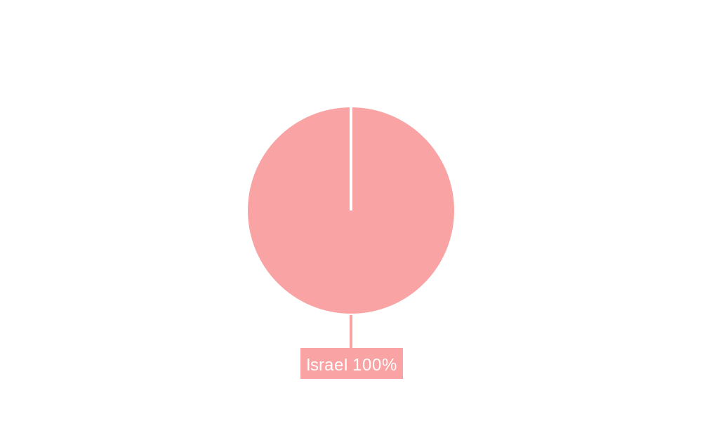
Israel Satellite Imagery Services Market Segmentation By Geography
- 1. Israel
Israel Satellite Imagery Services Market REPORT HIGHLIGHTS
| Aspects | Details |
|---|---|
| Study Period | 2019-2033 |
| Base Year | 2024 |
| Estimated Year | 2025 |
| Forecast Period | 2025-2033 |
| Historical Period | 2019-2024 |
| Growth Rate | CAGR of 8.63% from 2019-2033 |
| Segmentation |
|
Table of Contents
- 1. Introduction
- 1.1. Research Scope
- 1.2. Market Segmentation
- 1.3. Research Methodology
- 1.4. Definitions and Assumptions
- 2. Executive Summary
- 2.1. Introduction
- 3. Market Dynamics
- 3.1. Introduction
- 3.2. Market Drivers
- 3.2.1. Increasing Adoption of Location-based Services; Satellite data usage is increasing
- 3.3. Market Restrains
- 3.3.1. Strict government regulations; High-resolution Images Offered by Other Imaging Technologies
- 3.4. Market Trends
- 3.4.1. Surveillance and Security is Expected to Hold Significant Share
- 4. Market Factor Analysis
- 4.1. Porters Five Forces
- 4.2. Supply/Value Chain
- 4.3. PESTEL analysis
- 4.4. Market Entropy
- 4.5. Patent/Trademark Analysis
- 5. Israel Satellite Imagery Services Market Analysis, Insights and Forecast, 2019-2031
- 5.1. Market Analysis, Insights and Forecast - by Application
- 5.1.1. Geospatial Data Acquisition and Mapping
- 5.1.2. Natural Resource Management
- 5.1.3. Surveillance and Security
- 5.1.4. Conservation and Research
- 5.1.5. Disaster Management
- 5.1.6. Intelligence
- 5.2. Market Analysis, Insights and Forecast - by End-User
- 5.2.1. Government
- 5.2.2. Construction
- 5.2.3. Transportation and Logistics
- 5.2.4. Military and Defense
- 5.2.5. Forestry and Agriculture
- 5.2.6. Others
- 5.3. Market Analysis, Insights and Forecast - by Region
- 5.3.1. Israel
- 5.1. Market Analysis, Insights and Forecast - by Application
- 6. Competitive Analysis
- 6.1. Market Share Analysis 2024
- 6.2. Company Profiles
- 6.2.1 ImageSat International N V (iSi)
- 6.2.1.1. Overview
- 6.2.1.2. Products
- 6.2.1.3. SWOT Analysis
- 6.2.1.4. Recent Developments
- 6.2.1.5. Financials (Based on Availability)
- 6.2.2 ESRI
- 6.2.2.1. Overview
- 6.2.2.2. Products
- 6.2.2.3. SWOT Analysis
- 6.2.2.4. Recent Developments
- 6.2.2.5. Financials (Based on Availability)
- 6.2.3 Airbus Group Inc
- 6.2.3.1. Overview
- 6.2.3.2. Products
- 6.2.3.3. SWOT Analysis
- 6.2.3.4. Recent Developments
- 6.2.3.5. Financials (Based on Availability)
- 6.2.4 Trimble Navigation
- 6.2.4.1. Overview
- 6.2.4.2. Products
- 6.2.4.3. SWOT Analysis
- 6.2.4.4. Recent Developments
- 6.2.4.5. Financials (Based on Availability)
- 6.2.5 Ofek Aerial Photography
- 6.2.5.1. Overview
- 6.2.5.2. Products
- 6.2.5.3. SWOT Analysis
- 6.2.5.4. Recent Developments
- 6.2.5.5. Financials (Based on Availability)
- 6.2.6 A TAL Satellite Imagery
- 6.2.6.1. Overview
- 6.2.6.2. Products
- 6.2.6.3. SWOT Analysis
- 6.2.6.4. Recent Developments
- 6.2.6.5. Financials (Based on Availability)
- 6.2.7 Google LLC
- 6.2.7.1. Overview
- 6.2.7.2. Products
- 6.2.7.3. SWOT Analysis
- 6.2.7.4. Recent Developments
- 6.2.7.5. Financials (Based on Availability)
- 6.2.8 L3 Harris corporation
- 6.2.8.1. Overview
- 6.2.8.2. Products
- 6.2.8.3. SWOT Analysis
- 6.2.8.4. Recent Developments
- 6.2.8.5. Financials (Based on Availability)
- 6.2.1 ImageSat International N V (iSi)
List of Figures
- Figure 1: Israel Satellite Imagery Services Market Revenue Breakdown (Million, %) by Product 2024 & 2032
- Figure 2: Israel Satellite Imagery Services Market Share (%) by Company 2024
List of Tables
- Table 1: Israel Satellite Imagery Services Market Revenue Million Forecast, by Region 2019 & 2032
- Table 2: Israel Satellite Imagery Services Market Revenue Million Forecast, by Application 2019 & 2032
- Table 3: Israel Satellite Imagery Services Market Revenue Million Forecast, by End-User 2019 & 2032
- Table 4: Israel Satellite Imagery Services Market Revenue Million Forecast, by Region 2019 & 2032
- Table 5: Israel Satellite Imagery Services Market Revenue Million Forecast, by Country 2019 & 2032
- Table 6: Israel Satellite Imagery Services Market Revenue Million Forecast, by Application 2019 & 2032
- Table 7: Israel Satellite Imagery Services Market Revenue Million Forecast, by End-User 2019 & 2032
- Table 8: Israel Satellite Imagery Services Market Revenue Million Forecast, by Country 2019 & 2032
Frequently Asked Questions
1. What is the projected Compound Annual Growth Rate (CAGR) of the Israel Satellite Imagery Services Market?
The projected CAGR is approximately 8.63%.
2. Which companies are prominent players in the Israel Satellite Imagery Services Market?
Key companies in the market include ImageSat International N V (iSi), ESRI, Airbus Group Inc, Trimble Navigation, Ofek Aerial Photography, A TAL Satellite Imagery, Google LLC, L3 Harris corporation.
3. What are the main segments of the Israel Satellite Imagery Services Market?
The market segments include Application, End-User.
4. Can you provide details about the market size?
The market size is estimated to be USD XX Million as of 2022.
5. What are some drivers contributing to market growth?
Increasing Adoption of Location-based Services; Satellite data usage is increasing.
6. What are the notable trends driving market growth?
Surveillance and Security is Expected to Hold Significant Share.
7. Are there any restraints impacting market growth?
Strict government regulations; High-resolution Images Offered by Other Imaging Technologies.
8. Can you provide examples of recent developments in the market?
July 2023: Maxar Technologies, a leading provider of comprehensive space services and secure, precise geospatial intelligence, officially unveiled its groundbreaking Maxar Geospatial Platform (MGP). This cutting-edge platform revolutionizes the accessibility of advanced Earth intelligence, streamlining the process of discovering, acquiring, and integrating geospatial data and analytics. MGP empowers users with seamless access to Maxar's unparalleled geospatial content, which encompasses high-resolution satellite imagery, visually striking imagery base maps, intricate 3D models, readily analyzable data, and image-based change detection and analytical results.
9. What pricing options are available for accessing the report?
Pricing options include single-user, multi-user, and enterprise licenses priced at USD 3800, USD 4500, and USD 5800 respectively.
10. Is the market size provided in terms of value or volume?
The market size is provided in terms of value, measured in Million.
11. Are there any specific market keywords associated with the report?
Yes, the market keyword associated with the report is "Israel Satellite Imagery Services Market," which aids in identifying and referencing the specific market segment covered.
12. How do I determine which pricing option suits my needs best?
The pricing options vary based on user requirements and access needs. Individual users may opt for single-user licenses, while businesses requiring broader access may choose multi-user or enterprise licenses for cost-effective access to the report.
13. Are there any additional resources or data provided in the Israel Satellite Imagery Services Market report?
While the report offers comprehensive insights, it's advisable to review the specific contents or supplementary materials provided to ascertain if additional resources or data are available.
14. How can I stay updated on further developments or reports in the Israel Satellite Imagery Services Market?
To stay informed about further developments, trends, and reports in the Israel Satellite Imagery Services Market, consider subscribing to industry newsletters, following relevant companies and organizations, or regularly checking reputable industry news sources and publications.
Methodology
Step 1 - Identification of Relevant Samples Size from Population Database


Step 2 - Approaches for Defining Global Market Size (Value, Volume* & Price*)

Note*: In applicable scenarios
Step 3 - Data Sources
Primary Research
- Web Analytics
- Survey Reports
- Research Institute
- Latest Research Reports
- Opinion Leaders
Secondary Research
- Annual Reports
- White Paper
- Latest Press Release
- Industry Association
- Paid Database
- Investor Presentations

Step 4 - Data Triangulation
Involves using different sources of information in order to increase the validity of a study
These sources are likely to be stakeholders in a program - participants, other researchers, program staff, other community members, and so on.
Then we put all data in single framework & apply various statistical tools to find out the dynamic on the market.
During the analysis stage, feedback from the stakeholder groups would be compared to determine areas of agreement as well as areas of divergence
