

Key Insights
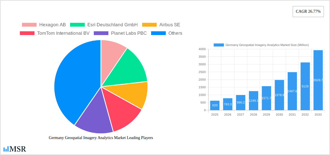
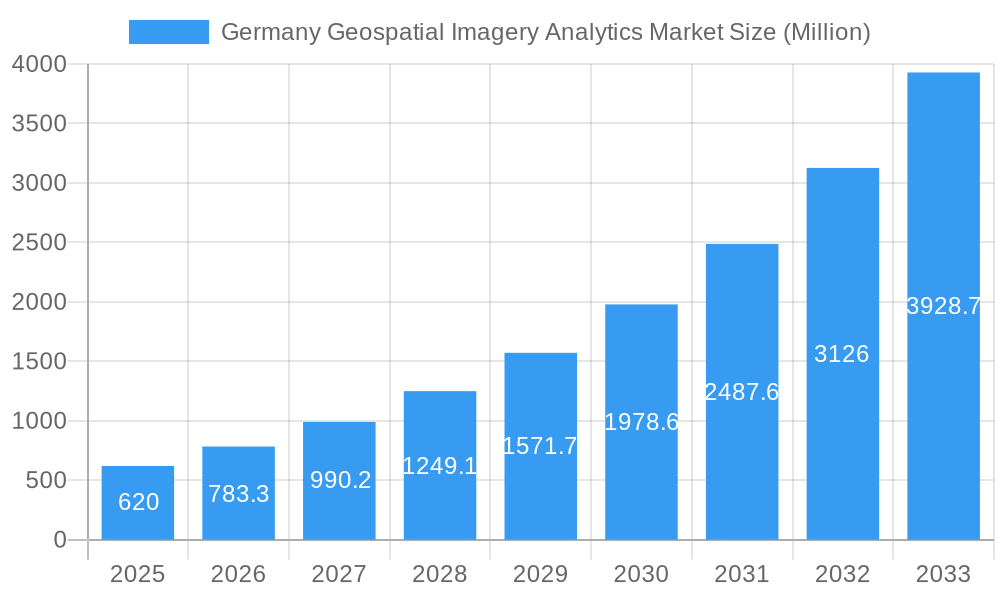
The German geospatial imagery analytics market is experiencing robust growth, projected to reach a market size of €620 million in 2025, exhibiting a Compound Annual Growth Rate (CAGR) of 26.77% from 2019 to 2033. This significant expansion is driven by increasing demand for precise location intelligence across diverse sectors. Key drivers include the burgeoning adoption of advanced technologies like AI and machine learning for enhanced image processing and analysis, coupled with rising government investments in infrastructure development and smart city initiatives. The market is witnessing a shift towards cloud-based solutions, offering scalability and cost-effectiveness. Furthermore, the integration of geospatial imagery analytics with other data sources, such as sensor data and social media feeds, is creating more comprehensive and insightful solutions, fueling market growth. The rising need for efficient resource management and environmental monitoring also contributes to the market's upward trajectory. Competitive landscape analysis reveals a mix of established players like Hexagon AB, Esri Deutschland GmbH, and Airbus SE, alongside emerging innovative companies such as Planet Labs PBC and smaller specialized firms. This competition fosters innovation and pushes the boundaries of geospatial analytics capabilities.
Germany Geospatial Imagery Analytics Market Market Size (In Million)
Looking ahead, the German market is poised for continued expansion. The projected CAGR suggests a substantial increase in market value over the forecast period (2025-2033). This growth will be further fueled by the expanding adoption of geospatial technologies across various industries such as agriculture, logistics, and defense. However, challenges remain, including data privacy concerns and the need for skilled professionals to effectively manage and interpret the complex data generated by geospatial imagery analytics systems. Nonetheless, the long-term outlook remains positive, with ongoing technological advancements and increasing awareness of the value of geospatial intelligence solidifying the market's position as a crucial component of Germany's digital transformation.
Germany Geospatial Imagery Analytics Market Company Market Share
Germany Geospatial Imagery Analytics Market: A Comprehensive Report (2019-2033)
This comprehensive report provides a detailed analysis of the Germany Geospatial Imagery Analytics Market, offering invaluable insights for industry stakeholders, investors, and businesses seeking to capitalize on this rapidly evolving sector. The report covers the period 2019-2033, with a base year of 2025 and a forecast period of 2025-2033. The market is poised for significant growth, driven by technological advancements and increasing demand across various sectors. The report analyzes market dynamics, key segments, leading players, and emerging opportunities, offering a 360° view of this dynamic market.
Germany Geospatial Imagery Analytics Market Concentration & Dynamics
The German geospatial imagery analytics market exhibits a moderately concentrated landscape, with a few major players holding significant market share. However, the presence of numerous smaller, specialized firms fosters innovation and competition. The market is characterized by a dynamic interplay of factors including:
Market Concentration:
- The top 5 players account for approximately xx% of the market share in 2025 (Estimated Year).
- The market exhibits a moderate Herfindahl-Hirschman Index (HHI) of xx, suggesting a competitive but not overly fragmented structure.
Innovation Ecosystems:
- Germany boasts a robust ecosystem of research institutions, startups, and established companies driving innovation in areas like AI, machine learning, and high-resolution imagery.
- Government initiatives supporting the development of space technology and geospatial data infrastructure further fuel innovation.
Regulatory Frameworks:
- Existing regulations concerning data privacy (GDPR) and data security impact market practices and data handling procedures.
- Emerging regulations, such as the EU Deforestation Regulation (EUDR), are creating new opportunities for specialized analytics solutions.
Substitute Products:
- Traditional surveying and mapping methods act as substitutes, although their efficiency and cost-effectiveness are often outweighed by geospatial analytics solutions.
- The increasing availability of open-source geospatial data creates a degree of substitution, but often lacks the precision and analytical capabilities offered by commercial solutions.
End-User Trends:
- Growing demand across sectors like agriculture, infrastructure, urban planning, and environmental monitoring drives market expansion.
- The increasing adoption of cloud-based solutions is shaping market trends, facilitating data accessibility and scalability.
M&A Activities:
- The number of M&A deals in the German geospatial imagery analytics market totalled xx in the historical period (2019-2024), indicating consolidation and strategic expansion.
- Future M&A activity is expected to increase, driven by the need for companies to expand their capabilities and market reach.
Germany Geospatial Imagery Analytics Market Industry Insights & Trends
The German geospatial imagery analytics market is witnessing robust growth, with the market size estimated at €xx Million in 2025 (Estimated Year) and projected to reach €xx Million by 2033, exhibiting a Compound Annual Growth Rate (CAGR) of xx% during the forecast period (2025-2033). This expansion is propelled by several key factors:
- Technological advancements: Innovations in satellite technology, sensor technology, AI, and machine learning are enhancing the accuracy, resolution, and analytical capabilities of geospatial imagery.
- Increasing data availability: The growth of readily accessible satellite imagery and aerial photography provides a wealth of data for analysis, fueling market expansion.
- Rising demand across sectors: Across diverse industries including agriculture, urban planning, infrastructure development, environmental monitoring, and defense, there is a growing need for actionable insights derived from geospatial data.
- Government initiatives: Government funding and support for research and development in geospatial technologies further boosts market growth.
- Evolving consumer behaviors: Increasing reliance on data-driven decision-making, especially in sectors sensitive to environmental or infrastructural changes, underscores the relevance of geospatial analytics.
Key Markets & Segments Leading Germany Geospatial Imagery Analytics Market
The German geospatial imagery analytics market demonstrates robust growth across multiple segments, but certain sectors stand out:
- Dominant Segment: The infrastructure sector, comprising transportation, utilities, and construction, is currently the largest segment, driving substantial market demand. This is fueled by the need for efficient infrastructure management and planning. The urban planning segment also represents significant growth, due to Germany's focus on sustainable urban development.
Drivers for Dominant Segments:
- Economic Growth: Continued economic growth in Germany supports infrastructure development and urban expansion, boosting the demand for geospatial analytics.
- Infrastructure Development: Investments in modernizing and expanding transportation networks, energy grids, and other infrastructure facilities drive market growth.
- Urbanization: The trend towards urbanization and the need for efficient urban planning create a substantial demand for geospatial data analysis.
- Environmental Concerns: The increasing awareness of environmental issues is leading to greater investments in environmental monitoring and management, which depend heavily on geospatial analytics.
Germany Geospatial Imagery Analytics Market Product Developments
Recent product developments in the German market highlight the increasing sophistication and application of geospatial imagery analytics. Advancements in AI-powered image processing, cloud-based analytics platforms, and specialized software solutions are transforming the market. These improvements offer enhanced accuracy, faster processing speeds, and more user-friendly interfaces, expanding the accessibility and application of geospatial data analysis across diverse sectors. The integration of different data sources, including sensor data and GIS systems, provides a more holistic and comprehensive approach to geospatial analysis.
Challenges in the Germany Geospatial Imagery Analytics Market Market
Several challenges impede the growth of the German geospatial imagery analytics market:
- Data Privacy Regulations: Strict data privacy regulations (GDPR) necessitate careful consideration of data handling and security, adding complexity to project implementation.
- High Initial Investment Costs: The cost of acquiring high-resolution imagery and advanced analytics software can be substantial, representing a barrier to entry for smaller businesses.
- Skill Shortages: A lack of skilled professionals proficient in geospatial data analysis can limit the growth and adoption of advanced technologies.
- Data Integration Complexity: Integrating geospatial data from diverse sources can be challenging, requiring expertise in data management and processing techniques.
Forces Driving Germany Geospatial Imagery Analytics Market Growth
Several factors are accelerating the growth of the German geospatial imagery analytics market:
- Technological Advancements: Continuous advancements in AI, machine learning, and high-resolution satellite imagery are revolutionizing the capabilities of geospatial analysis.
- Government Support: Government initiatives and funding for research and development in space technology and geospatial data are driving innovation and market expansion.
- Increasing Demand: The growing need for precise geospatial data across diverse sectors, from agriculture and urban planning to infrastructure development, fuels market growth.
- Cloud Computing: Cloud-based platforms are simplifying data access and processing, making geospatial analytics more accessible to a broader range of users.
Long-Term Growth Catalysts in Germany Geospatial Imagery Analytics Market
The long-term growth of the German geospatial imagery analytics market is propelled by a multitude of factors. Continued innovation in AI and machine learning will result in more sophisticated analytical capabilities. Strategic partnerships between technology providers and end-users will foster the development of tailored solutions. Market expansion into new sectors, such as precision agriculture and smart cities, will further fuel growth.
Emerging Opportunities in Germany Geospatial Imagery Analytics Market
Emerging opportunities in the German geospatial imagery analytics market include the expansion of applications into new sectors, such as precision agriculture and smart city development. The increasing adoption of AI and machine learning for automating data analysis and extraction is also creating significant opportunities. Furthermore, the integration of geospatial data with other data sources, such as IoT sensor data, is leading to the development of innovative solutions for various applications.
Leading Players in the Germany Geospatial Imagery Analytics Market Sector
- Hexagon AB
- Esri Deutschland GmbH
- Airbus SE
- TomTom International BV
- Planet Labs PBC
- Oracle Corporation
- BAE Systems
- Maxar Technologies
- Microsoft Corporation
- Google LLC *List Not Exhaustive
Key Milestones in Germany Geospatial Imagery Analytics Market Industry
- September 2023: European Space Imaging (EUSI) partnered with Umbra, enhancing SAR data availability in Germany and stimulating market growth.
- January 2024: LiveEO launched its EUDR Expert, an AI-powered compliance solution addressing the EU Deforestation Regulation (EUDR), creating new market opportunities.
Strategic Outlook for Germany Geospatial Imagery Analytics Market Market
The German geospatial imagery analytics market presents significant growth potential driven by technological advancements, increasing data availability, and rising demand across diverse sectors. Strategic opportunities for businesses include developing innovative AI-powered solutions, expanding into new applications, and forging strategic partnerships to capitalize on this dynamic market. The focus on data privacy and security will continue to be paramount, requiring companies to invest in robust data management and security measures.
Germany Geospatial Imagery Analytics Market Segmentation
-
1. Type
- 1.1. Imagery Analytics
- 1.2. Video Analytics
-
2. Deployment Mode
- 2.1. On-premise
- 2.2. Cloud
-
3. Organization Size
- 3.1. SMEs
- 3.2. Large Enterprises
-
4. Verticals
- 4.1. Insurance
- 4.2. Agriculture
- 4.3. Defense and Security
- 4.4. Environmental Monitoring
- 4.5. Engineering and Construction
- 4.6. Government
- 4.7. Other Verticals
Germany Geospatial Imagery Analytics Market Segmentation By Geography
- 1. Germany
Germany Geospatial Imagery Analytics Market Regional Market Share
Geographic Coverage of Germany Geospatial Imagery Analytics Market
Germany Geospatial Imagery Analytics Market REPORT HIGHLIGHTS
| Aspects | Details |
|---|---|
| Study Period | 2020-2034 |
| Base Year | 2025 |
| Estimated Year | 2026 |
| Forecast Period | 2026-2034 |
| Historical Period | 2020-2025 |
| Growth Rate | CAGR of 26.77% from 2020-2034 |
| Segmentation |
|
Table of Contents
- 1. Introduction
- 1.1. Research Scope
- 1.2. Market Segmentation
- 1.3. Research Methodology
- 1.4. Definitions and Assumptions
- 2. Executive Summary
- 2.1. Introduction
- 3. Market Dynamics
- 3.1. Introduction
- 3.2. Market Drivers
- 3.2.1 The Growth of Infrastructure Development and Urban Planning in the Country; The Growing Demand for High-resolution Satellite Data for Crisis Response
- 3.2.2 Environmental Monitoring
- 3.2.3 and Nature Conservation Efforts
- 3.3. Market Restrains
- 3.3.1 The Growth of Infrastructure Development and Urban Planning in the Country; The Growing Demand for High-resolution Satellite Data for Crisis Response
- 3.3.2 Environmental Monitoring
- 3.3.3 and Nature Conservation Efforts
- 3.4. Market Trends
- 3.4.1. Imagery Analytics Contributes Significantly to the Market Share
- 4. Market Factor Analysis
- 4.1. Porters Five Forces
- 4.2. Supply/Value Chain
- 4.3. PESTEL analysis
- 4.4. Market Entropy
- 4.5. Patent/Trademark Analysis
- 5. Germany Geospatial Imagery Analytics Market Analysis, Insights and Forecast, 2020-2032
- 5.1. Market Analysis, Insights and Forecast - by Type
- 5.1.1. Imagery Analytics
- 5.1.2. Video Analytics
- 5.2. Market Analysis, Insights and Forecast - by Deployment Mode
- 5.2.1. On-premise
- 5.2.2. Cloud
- 5.3. Market Analysis, Insights and Forecast - by Organization Size
- 5.3.1. SMEs
- 5.3.2. Large Enterprises
- 5.4. Market Analysis, Insights and Forecast - by Verticals
- 5.4.1. Insurance
- 5.4.2. Agriculture
- 5.4.3. Defense and Security
- 5.4.4. Environmental Monitoring
- 5.4.5. Engineering and Construction
- 5.4.6. Government
- 5.4.7. Other Verticals
- 5.5. Market Analysis, Insights and Forecast - by Region
- 5.5.1. Germany
- 5.1. Market Analysis, Insights and Forecast - by Type
- 6. Competitive Analysis
- 6.1. Market Share Analysis 2025
- 6.2. Company Profiles
- 6.2.1 Hexagon AB
- 6.2.1.1. Overview
- 6.2.1.2. Products
- 6.2.1.3. SWOT Analysis
- 6.2.1.4. Recent Developments
- 6.2.1.5. Financials (Based on Availability)
- 6.2.2 Esri Deutschland GmbH
- 6.2.2.1. Overview
- 6.2.2.2. Products
- 6.2.2.3. SWOT Analysis
- 6.2.2.4. Recent Developments
- 6.2.2.5. Financials (Based on Availability)
- 6.2.3 Airbus SE
- 6.2.3.1. Overview
- 6.2.3.2. Products
- 6.2.3.3. SWOT Analysis
- 6.2.3.4. Recent Developments
- 6.2.3.5. Financials (Based on Availability)
- 6.2.4 TomTom International BV
- 6.2.4.1. Overview
- 6.2.4.2. Products
- 6.2.4.3. SWOT Analysis
- 6.2.4.4. Recent Developments
- 6.2.4.5. Financials (Based on Availability)
- 6.2.5 Planet Labs PBC
- 6.2.5.1. Overview
- 6.2.5.2. Products
- 6.2.5.3. SWOT Analysis
- 6.2.5.4. Recent Developments
- 6.2.5.5. Financials (Based on Availability)
- 6.2.6 Oracle Corporation
- 6.2.6.1. Overview
- 6.2.6.2. Products
- 6.2.6.3. SWOT Analysis
- 6.2.6.4. Recent Developments
- 6.2.6.5. Financials (Based on Availability)
- 6.2.7 BAE Systems
- 6.2.7.1. Overview
- 6.2.7.2. Products
- 6.2.7.3. SWOT Analysis
- 6.2.7.4. Recent Developments
- 6.2.7.5. Financials (Based on Availability)
- 6.2.8 Maxar Technologies
- 6.2.8.1. Overview
- 6.2.8.2. Products
- 6.2.8.3. SWOT Analysis
- 6.2.8.4. Recent Developments
- 6.2.8.5. Financials (Based on Availability)
- 6.2.9 Microsoft Corporation
- 6.2.9.1. Overview
- 6.2.9.2. Products
- 6.2.9.3. SWOT Analysis
- 6.2.9.4. Recent Developments
- 6.2.9.5. Financials (Based on Availability)
- 6.2.10 Google LLC*List Not Exhaustive
- 6.2.10.1. Overview
- 6.2.10.2. Products
- 6.2.10.3. SWOT Analysis
- 6.2.10.4. Recent Developments
- 6.2.10.5. Financials (Based on Availability)
- 6.2.1 Hexagon AB
List of Figures
- Figure 1: Germany Geospatial Imagery Analytics Market Revenue Breakdown (Million, %) by Product 2025 & 2033
- Figure 2: Germany Geospatial Imagery Analytics Market Share (%) by Company 2025
List of Tables
- Table 1: Germany Geospatial Imagery Analytics Market Revenue Million Forecast, by Type 2020 & 2033
- Table 2: Germany Geospatial Imagery Analytics Market Volume Billion Forecast, by Type 2020 & 2033
- Table 3: Germany Geospatial Imagery Analytics Market Revenue Million Forecast, by Deployment Mode 2020 & 2033
- Table 4: Germany Geospatial Imagery Analytics Market Volume Billion Forecast, by Deployment Mode 2020 & 2033
- Table 5: Germany Geospatial Imagery Analytics Market Revenue Million Forecast, by Organization Size 2020 & 2033
- Table 6: Germany Geospatial Imagery Analytics Market Volume Billion Forecast, by Organization Size 2020 & 2033
- Table 7: Germany Geospatial Imagery Analytics Market Revenue Million Forecast, by Verticals 2020 & 2033
- Table 8: Germany Geospatial Imagery Analytics Market Volume Billion Forecast, by Verticals 2020 & 2033
- Table 9: Germany Geospatial Imagery Analytics Market Revenue Million Forecast, by Region 2020 & 2033
- Table 10: Germany Geospatial Imagery Analytics Market Volume Billion Forecast, by Region 2020 & 2033
- Table 11: Germany Geospatial Imagery Analytics Market Revenue Million Forecast, by Type 2020 & 2033
- Table 12: Germany Geospatial Imagery Analytics Market Volume Billion Forecast, by Type 2020 & 2033
- Table 13: Germany Geospatial Imagery Analytics Market Revenue Million Forecast, by Deployment Mode 2020 & 2033
- Table 14: Germany Geospatial Imagery Analytics Market Volume Billion Forecast, by Deployment Mode 2020 & 2033
- Table 15: Germany Geospatial Imagery Analytics Market Revenue Million Forecast, by Organization Size 2020 & 2033
- Table 16: Germany Geospatial Imagery Analytics Market Volume Billion Forecast, by Organization Size 2020 & 2033
- Table 17: Germany Geospatial Imagery Analytics Market Revenue Million Forecast, by Verticals 2020 & 2033
- Table 18: Germany Geospatial Imagery Analytics Market Volume Billion Forecast, by Verticals 2020 & 2033
- Table 19: Germany Geospatial Imagery Analytics Market Revenue Million Forecast, by Country 2020 & 2033
- Table 20: Germany Geospatial Imagery Analytics Market Volume Billion Forecast, by Country 2020 & 2033
Frequently Asked Questions
1. What is the projected Compound Annual Growth Rate (CAGR) of the Germany Geospatial Imagery Analytics Market?
The projected CAGR is approximately 26.77%.
2. Which companies are prominent players in the Germany Geospatial Imagery Analytics Market?
Key companies in the market include Hexagon AB, Esri Deutschland GmbH, Airbus SE, TomTom International BV, Planet Labs PBC, Oracle Corporation, BAE Systems, Maxar Technologies, Microsoft Corporation, Google LLC*List Not Exhaustive.
3. What are the main segments of the Germany Geospatial Imagery Analytics Market?
The market segments include Type, Deployment Mode, Organization Size, Verticals.
4. Can you provide details about the market size?
The market size is estimated to be USD 0.62 Million as of 2022.
5. What are some drivers contributing to market growth?
The Growth of Infrastructure Development and Urban Planning in the Country; The Growing Demand for High-resolution Satellite Data for Crisis Response. Environmental Monitoring. and Nature Conservation Efforts.
6. What are the notable trends driving market growth?
Imagery Analytics Contributes Significantly to the Market Share.
7. Are there any restraints impacting market growth?
The Growth of Infrastructure Development and Urban Planning in the Country; The Growing Demand for High-resolution Satellite Data for Crisis Response. Environmental Monitoring. and Nature Conservation Efforts.
8. Can you provide examples of recent developments in the market?
January 2024 - LiveEO, a Berlin-based Earth observation scaleup company that specializes in using AI to analyze Earth observation data in support of critical transport and energy infrastructure, launched its EUDR Expert. It is an AI compliance advisor solution that helps understand the complexities and challenges that clients face with the EU Deforestation Regulation (EUDR).
9. What pricing options are available for accessing the report?
Pricing options include single-user, multi-user, and enterprise licenses priced at USD 3800, USD 4500, and USD 5800 respectively.
10. Is the market size provided in terms of value or volume?
The market size is provided in terms of value, measured in Million and volume, measured in Billion.
11. Are there any specific market keywords associated with the report?
Yes, the market keyword associated with the report is "Germany Geospatial Imagery Analytics Market," which aids in identifying and referencing the specific market segment covered.
12. How do I determine which pricing option suits my needs best?
The pricing options vary based on user requirements and access needs. Individual users may opt for single-user licenses, while businesses requiring broader access may choose multi-user or enterprise licenses for cost-effective access to the report.
13. Are there any additional resources or data provided in the Germany Geospatial Imagery Analytics Market report?
While the report offers comprehensive insights, it's advisable to review the specific contents or supplementary materials provided to ascertain if additional resources or data are available.
14. How can I stay updated on further developments or reports in the Germany Geospatial Imagery Analytics Market?
To stay informed about further developments, trends, and reports in the Germany Geospatial Imagery Analytics Market, consider subscribing to industry newsletters, following relevant companies and organizations, or regularly checking reputable industry news sources and publications.
Methodology
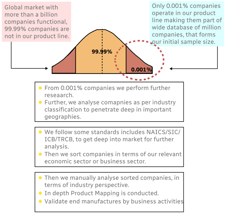
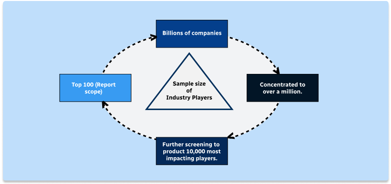
Step 1 - Identification of Relevant Samples Size from Population Database
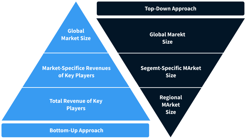
Step 2 - Approaches for Defining Global Market Size (Value, Volume* & Price*)
Note*: In applicable scenarios
Step 3 - Data Sources
Primary Research
- Web Analytics
- Survey Reports
- Research Institute
- Latest Research Reports
- Opinion Leaders
Secondary Research
- Annual Reports
- White Paper
- Latest Press Release
- Industry Association
- Paid Database
- Investor Presentations
Step 4 - Data Triangulation
Involves using different sources of information in order to increase the validity of a study
These sources are likely to be stakeholders in a program - participants, other researchers, program staff, other community members, and so on.
Then we put all data in single framework & apply various statistical tools to find out the dynamic on the market.
During the analysis stage, feedback from the stakeholder groups would be compared to determine areas of agreement as well as areas of divergence