

Key Insights
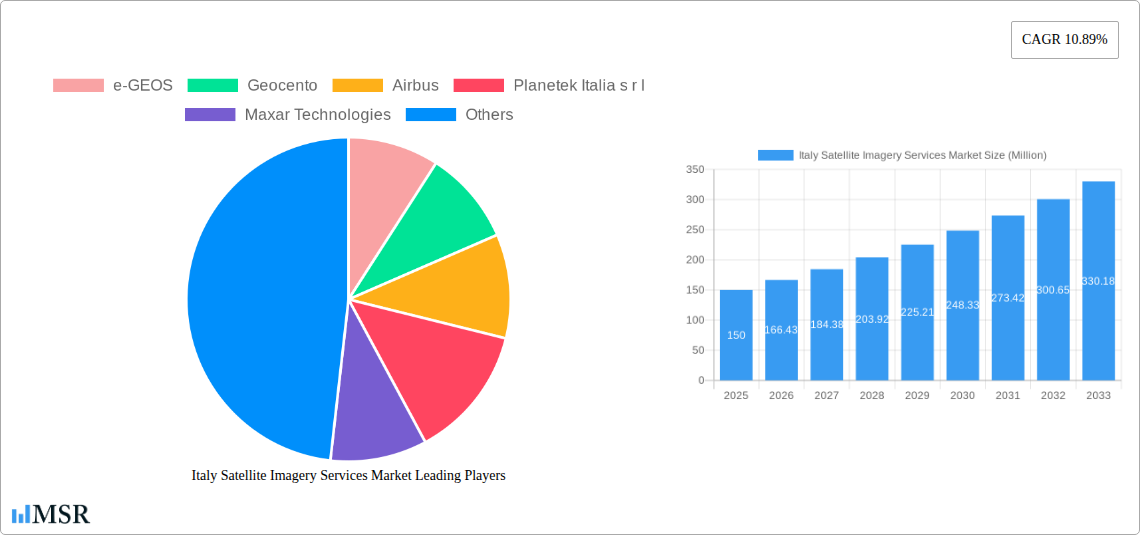
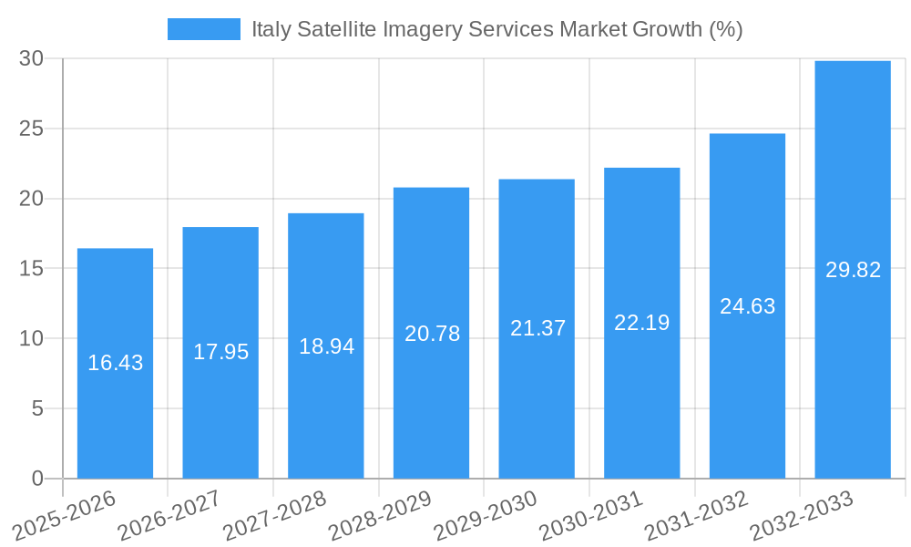
The Italian satellite imagery services market, valued at approximately €150 million in 2025, is poised for robust growth, exhibiting a Compound Annual Growth Rate (CAGR) of 10.89% from 2025 to 2033. This expansion is driven by increasing government investments in infrastructure projects, particularly in transportation and construction, coupled with rising demand for precise geospatial data across various sectors. The surge in demand for efficient natural resource management, enhanced surveillance and security solutions, and effective disaster response mechanisms are key factors fueling market growth. Furthermore, the Italian government's commitment to technological advancement and digitalization initiatives, including those related to environmental monitoring and urban planning, creates a favorable environment for the satellite imagery services industry. The market is segmented by application (geospatial data acquisition & mapping, natural resource management, surveillance & security, conservation & research, disaster management, intelligence) and end-user (government, construction, transportation & logistics, military & defense, forestry & agriculture, others). Leading players like e-GEOS, Geocento, Airbus, and Maxar Technologies are actively contributing to market expansion through technological innovations and strategic partnerships, further solidifying Italy's position within the European satellite imagery landscape.
The market's growth trajectory is expected to be further propelled by advancements in satellite technology, resulting in higher resolution imagery and more efficient data processing capabilities. However, potential restraints include data privacy concerns, the high initial investment costs associated with satellite imagery acquisition and analysis, and the need for skilled professionals to interpret and utilize the data effectively. Despite these challenges, the long-term outlook for the Italian satellite imagery services market remains positive, driven by increasing government support and a rising awareness of the critical role of geospatial intelligence across diverse sectors. The market's segmentation offers opportunities for specialized service providers to cater to the specific needs of various end-users, leading to further market fragmentation and specialized service offerings.
Italy Satellite Imagery Services Market: A Comprehensive Report (2019-2033)
This in-depth report provides a comprehensive analysis of the Italy Satellite Imagery Services Market, offering invaluable insights for stakeholders across the geospatial intelligence, defense, and environmental sectors. Covering the period 2019-2033, with a focus on 2025, this report dissects market dynamics, key segments, leading players, and emerging opportunities. The report uses Million for all values.
Italy Satellite Imagery Services Market Concentration & Dynamics
The Italy Satellite Imagery Services Market exhibits a moderately concentrated landscape, with key players like e-GEOS, Geocento, Airbus, Planetek Italia s.r.l., Maxar Technologies, L3Harris Technologies, Viasat Group S.p.A, EUSI, Thales Alenia Space, and OHB-Italia S.p.A. holding significant market share. However, the presence of numerous smaller, specialized firms contributes to a dynamic competitive environment. Market concentration is estimated at xx% in 2025.
The market's innovation ecosystem is robust, driven by advancements in sensor technology, satellite constellations, and data analytics. Regulatory frameworks, primarily those governing data privacy and national security, play a significant role. Substitute products, such as aerial photography and LiDAR, exert some competitive pressure. End-user trends reveal a growing demand for high-resolution imagery across various sectors, including government, defense, and agriculture. M&A activity within the sector remains relatively moderate, with xx major deals recorded between 2019 and 2024.
- Market Share: Dominant players hold approximately xx% of the market in 2025.
- M&A Activity: An average of xx M&A deals per year were recorded during 2019-2024.
- Innovation: Significant investments in AI-powered image processing and analysis are driving innovation.
- Regulatory Landscape: Stringent data privacy regulations impact data acquisition and usage.
Italy Satellite Imagery Services Market Industry Insights & Trends
The Italy Satellite Imagery Services Market is experiencing robust growth, driven by increasing demand for high-resolution imagery across multiple applications. The market size reached xx Million in 2025, projected to reach xx Million by 2033, exhibiting a CAGR of xx% during the forecast period (2025-2033). This growth is fueled by several factors, including government initiatives promoting the use of geospatial data, rising investments in infrastructure development, and increasing adoption of satellite imagery for disaster management and environmental monitoring.
Technological advancements, such as the development of miniaturized satellites and improved sensor technologies, are further stimulating market expansion. The increasing accessibility and affordability of satellite imagery are making it a viable option for a wider range of users. Evolving consumer behavior shows a preference for cloud-based data delivery and integrated analytical solutions.
Key Markets & Segments Leading Italy Satellite Imagery Services Market
The Government sector is a dominant end-user, accounting for a significant portion of the market share, driven by national security, environmental monitoring, and urban planning initiatives. The Geospatial Data Acquisition and Mapping application segment is also a key driver, fuelled by the needs of urban development, infrastructure projects, and precision agriculture.
- Dominant End-User: Government
- Dominant Application: Geospatial Data Acquisition and Mapping
Drivers for Government Sector:
- Robust public spending on national security and defense.
- Increasing need for effective disaster management and response.
- Initiatives promoting the use of geospatial data for urban planning.
Drivers for Geospatial Data Acquisition and Mapping:
- Expanding construction and infrastructure development projects.
- Growing need for precise land surveying and mapping.
- Increasing adoption of GIS and other geospatial technologies.
Other significant application segments include Natural Resource Management, Surveillance and Security, and Disaster Management.
Italy Satellite Imagery Services Market Product Developments
Significant advancements in sensor technology have led to improved image resolution, spectral capabilities, and data processing speed. The emergence of constellations of smaller, more affordable satellites is increasing data availability and lowering costs. The integration of AI and machine learning in image processing and analytics is enhancing the value derived from satellite imagery. This trend is driving the competitiveness of the market.
Challenges in the Italy Satellite Imagery Services Market Market
The market faces challenges including data security concerns, dependence on international satellite operators for certain services, and the need for increased investment in domestic satellite infrastructure and skilled personnel. Regulatory hurdles in data access and processing pose further limitations, while the competitive pressure from established players and new entrants necessitates constant innovation and cost optimization. These factors can impact overall market penetration and expansion rates.
Forces Driving Italy Satellite Imagery Services Market Growth
The market's growth is propelled by strong government support for space technology, increasing private sector investment in geospatial data applications, and advancements in data processing techniques that enable faster and more efficient analyses. The rising adoption of satellite imagery for climate change monitoring and environmental sustainability initiatives also stimulates demand. National security concerns and the need for improved surveillance further contribute to market expansion.
Long-Term Growth Catalysts in the Italy Satellite Imagery Services Market
Long-term growth hinges on continuous technological innovation, strategic partnerships between private companies and research institutions, and expansion into new markets like precision agriculture and environmental monitoring. Investments in domestic satellite infrastructure and skilled workforce development are critical for sustainable growth.
Emerging Opportunities in Italy Satellite Imagery Services Market
Emerging opportunities lie in the application of satellite imagery for precision agriculture, smart city development, and environmental monitoring. The increasing demand for real-time data analysis and the development of value-added services present significant market potential. Expansion into underserved sectors and the development of tailored solutions for specific user needs offer attractive avenues for growth.
Leading Players in the Italy Satellite Imagery Services Market Sector
- e-GEOS
- Geocento
- Airbus
- Planetek Italia s.r.l
- Maxar Technologies
- L3Harris Technologies
- Viasat Group S.p.A
- EUSI
- Thales Alenia Space
- OHB-Italia S.p.A
Key Milestones in Italy Satellite Imagery Services Market Industry
- October 2022: Sentinel-2 satellite captures Stromboli volcano eruption, highlighting the real-time applications of satellite imagery in disaster management.
- March 2023: Arianespace secures contract for launching the IRIDE constellation, signaling significant investment in Italian satellite technology and expanding capacity. This will significantly impact the market from late 2025 onwards.
Strategic Outlook for Italy Satellite Imagery Services Market Market
The Italy Satellite Imagery Services Market holds significant future potential, driven by technological advancements, increasing data accessibility, and expanding applications across various sectors. Strategic opportunities lie in leveraging technological innovations, forging strategic alliances, and capitalizing on government initiatives to establish a strong domestic satellite imagery sector. The market is poised for continued growth and expansion in the coming years.
Italy Satellite Imagery Services Market Segmentation
-
1. Application
- 1.1. Geospatial Data Acquisition and Mapping
- 1.2. Natural Resource Management
- 1.3. Surveillance and Security
- 1.4. Conservation and Research
- 1.5. Disaster Management
- 1.6. Intelligence
-
2. End-User
- 2.1. Government
- 2.2. Construction
- 2.3. Transportation and Logistics
- 2.4. Military and Defense
- 2.5. Forestry and Agriculture
- 2.6. Others
Italy Satellite Imagery Services Market Segmentation By Geography
- 1. Italy
Italy Satellite Imagery Services Market REPORT HIGHLIGHTS
| Aspects | Details |
|---|---|
| Study Period | 2019-2033 |
| Base Year | 2024 |
| Estimated Year | 2025 |
| Forecast Period | 2025-2033 |
| Historical Period | 2019-2024 |
| Growth Rate | CAGR of 10.89% from 2019-2033 |
| Segmentation |
|
Table of Contents
- 1. Introduction
- 1.1. Research Scope
- 1.2. Market Segmentation
- 1.3. Research Methodology
- 1.4. Definitions and Assumptions
- 2. Executive Summary
- 2.1. Introduction
- 3. Market Dynamics
- 3.1. Introduction
- 3.2. Market Drivers
- 3.2.1. Increasing Investments to Strengthen Country's Space Economy; Adoption of Big Data and Imagery Analytics
- 3.3. Market Restrains
- 3.3.1. High Cost of Satellite Imaging Data Acquisition and Processing
- 3.4. Market Trends
- 3.4.1. Disaster Management Segment is Expected to Hold Significant Market Share
- 4. Market Factor Analysis
- 4.1. Porters Five Forces
- 4.2. Supply/Value Chain
- 4.3. PESTEL analysis
- 4.4. Market Entropy
- 4.5. Patent/Trademark Analysis
- 5. Italy Satellite Imagery Services Market Analysis, Insights and Forecast, 2019-2031
- 5.1. Market Analysis, Insights and Forecast - by Application
- 5.1.1. Geospatial Data Acquisition and Mapping
- 5.1.2. Natural Resource Management
- 5.1.3. Surveillance and Security
- 5.1.4. Conservation and Research
- 5.1.5. Disaster Management
- 5.1.6. Intelligence
- 5.2. Market Analysis, Insights and Forecast - by End-User
- 5.2.1. Government
- 5.2.2. Construction
- 5.2.3. Transportation and Logistics
- 5.2.4. Military and Defense
- 5.2.5. Forestry and Agriculture
- 5.2.6. Others
- 5.3. Market Analysis, Insights and Forecast - by Region
- 5.3.1. Italy
- 5.1. Market Analysis, Insights and Forecast - by Application
- 6. Competitive Analysis
- 6.1. Market Share Analysis 2024
- 6.2. Company Profiles
- 6.2.1 e-GEOS
- 6.2.1.1. Overview
- 6.2.1.2. Products
- 6.2.1.3. SWOT Analysis
- 6.2.1.4. Recent Developments
- 6.2.1.5. Financials (Based on Availability)
- 6.2.2 Geocento
- 6.2.2.1. Overview
- 6.2.2.2. Products
- 6.2.2.3. SWOT Analysis
- 6.2.2.4. Recent Developments
- 6.2.2.5. Financials (Based on Availability)
- 6.2.3 Airbus
- 6.2.3.1. Overview
- 6.2.3.2. Products
- 6.2.3.3. SWOT Analysis
- 6.2.3.4. Recent Developments
- 6.2.3.5. Financials (Based on Availability)
- 6.2.4 Planetek Italia s r l
- 6.2.4.1. Overview
- 6.2.4.2. Products
- 6.2.4.3. SWOT Analysis
- 6.2.4.4. Recent Developments
- 6.2.4.5. Financials (Based on Availability)
- 6.2.5 Maxar Technologies
- 6.2.5.1. Overview
- 6.2.5.2. Products
- 6.2.5.3. SWOT Analysis
- 6.2.5.4. Recent Developments
- 6.2.5.5. Financials (Based on Availability)
- 6.2.6 L3Harris Technologies*List Not Exhaustive
- 6.2.6.1. Overview
- 6.2.6.2. Products
- 6.2.6.3. SWOT Analysis
- 6.2.6.4. Recent Developments
- 6.2.6.5. Financials (Based on Availability)
- 6.2.7 Viasat Group S p A
- 6.2.7.1. Overview
- 6.2.7.2. Products
- 6.2.7.3. SWOT Analysis
- 6.2.7.4. Recent Developments
- 6.2.7.5. Financials (Based on Availability)
- 6.2.8 EUSI
- 6.2.8.1. Overview
- 6.2.8.2. Products
- 6.2.8.3. SWOT Analysis
- 6.2.8.4. Recent Developments
- 6.2.8.5. Financials (Based on Availability)
- 6.2.9 Thales Alenia Space
- 6.2.9.1. Overview
- 6.2.9.2. Products
- 6.2.9.3. SWOT Analysis
- 6.2.9.4. Recent Developments
- 6.2.9.5. Financials (Based on Availability)
- 6.2.10 OHB-Italia S p A
- 6.2.10.1. Overview
- 6.2.10.2. Products
- 6.2.10.3. SWOT Analysis
- 6.2.10.4. Recent Developments
- 6.2.10.5. Financials (Based on Availability)
- 6.2.1 e-GEOS
List of Figures
- Figure 1: Italy Satellite Imagery Services Market Revenue Breakdown (Million, %) by Product 2024 & 2032
- Figure 2: Italy Satellite Imagery Services Market Share (%) by Company 2024
List of Tables
- Table 1: Italy Satellite Imagery Services Market Revenue Million Forecast, by Region 2019 & 2032
- Table 2: Italy Satellite Imagery Services Market Revenue Million Forecast, by Application 2019 & 2032
- Table 3: Italy Satellite Imagery Services Market Revenue Million Forecast, by End-User 2019 & 2032
- Table 4: Italy Satellite Imagery Services Market Revenue Million Forecast, by Region 2019 & 2032
- Table 5: Italy Satellite Imagery Services Market Revenue Million Forecast, by Country 2019 & 2032
- Table 6: Italy Satellite Imagery Services Market Revenue Million Forecast, by Application 2019 & 2032
- Table 7: Italy Satellite Imagery Services Market Revenue Million Forecast, by End-User 2019 & 2032
- Table 8: Italy Satellite Imagery Services Market Revenue Million Forecast, by Country 2019 & 2032
Frequently Asked Questions
1. What is the projected Compound Annual Growth Rate (CAGR) of the Italy Satellite Imagery Services Market?
The projected CAGR is approximately 10.89%.
2. Which companies are prominent players in the Italy Satellite Imagery Services Market?
Key companies in the market include e-GEOS, Geocento, Airbus, Planetek Italia s r l, Maxar Technologies, L3Harris Technologies*List Not Exhaustive, Viasat Group S p A, EUSI, Thales Alenia Space, OHB-Italia S p A.
3. What are the main segments of the Italy Satellite Imagery Services Market?
The market segments include Application, End-User.
4. Can you provide details about the market size?
The market size is estimated to be USD XX Million as of 2022.
5. What are some drivers contributing to market growth?
Increasing Investments to Strengthen Country's Space Economy; Adoption of Big Data and Imagery Analytics.
6. What are the notable trends driving market growth?
Disaster Management Segment is Expected to Hold Significant Market Share.
7. Are there any restraints impacting market growth?
High Cost of Satellite Imaging Data Acquisition and Processing.
8. Can you provide examples of recent developments in the market?
March 2023: Arianespace announced signing a contract with the European Space Agency (ESA), acting on behalf of the Italian government, for launching the IRIDE constellation of imaging satellites. The agreement includes two firm Vega C launches, starting in late 2025, with an option for a third. The Italian government funds the IRIDE constellation. It will consist of 36 satellites built by a consortium of Italian companies equipped with various imaging payloads, including optical and radar.
9. What pricing options are available for accessing the report?
Pricing options include single-user, multi-user, and enterprise licenses priced at USD 3800, USD 4500, and USD 5800 respectively.
10. Is the market size provided in terms of value or volume?
The market size is provided in terms of value, measured in Million.
11. Are there any specific market keywords associated with the report?
Yes, the market keyword associated with the report is "Italy Satellite Imagery Services Market," which aids in identifying and referencing the specific market segment covered.
12. How do I determine which pricing option suits my needs best?
The pricing options vary based on user requirements and access needs. Individual users may opt for single-user licenses, while businesses requiring broader access may choose multi-user or enterprise licenses for cost-effective access to the report.
13. Are there any additional resources or data provided in the Italy Satellite Imagery Services Market report?
While the report offers comprehensive insights, it's advisable to review the specific contents or supplementary materials provided to ascertain if additional resources or data are available.
14. How can I stay updated on further developments or reports in the Italy Satellite Imagery Services Market?
To stay informed about further developments, trends, and reports in the Italy Satellite Imagery Services Market, consider subscribing to industry newsletters, following relevant companies and organizations, or regularly checking reputable industry news sources and publications.
Methodology
Step 1 - Identification of Relevant Samples Size from Population Database


Step 2 - Approaches for Defining Global Market Size (Value, Volume* & Price*)

Note*: In applicable scenarios
Step 3 - Data Sources
Primary Research
- Web Analytics
- Survey Reports
- Research Institute
- Latest Research Reports
- Opinion Leaders
Secondary Research
- Annual Reports
- White Paper
- Latest Press Release
- Industry Association
- Paid Database
- Investor Presentations

Step 4 - Data Triangulation
Involves using different sources of information in order to increase the validity of a study
These sources are likely to be stakeholders in a program - participants, other researchers, program staff, other community members, and so on.
Then we put all data in single framework & apply various statistical tools to find out the dynamic on the market.
During the analysis stage, feedback from the stakeholder groups would be compared to determine areas of agreement as well as areas of divergence
